
Be the first to review this product
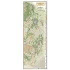
APPALACHIAN TRAIL: SWATARA GAP TO DELAWARE WATER GAP No.1507
The Swatara Gap to Delaware Water Gap Topographic Map Guidemakes a perfect traveling companion when traversing the northeastern Pennsylvania section of the Appalachian Trail (A.T.). The trail in this section of Pennsylvania primarily travels across flat, rocky ridges mixed with strenuous climbs in and out various gaps. Between Swatara Gap and Wind Gap, the A.T. weaves in and out of Pennsylvania State Game Lands as it follows the long ridge of Blue Mountain. From Wind Gap north, the A.T. follows the ridge of Kittatinny Mountain on its way to the Delaware Water Gap.
Each A.T. Topographic Map Guide includes detailed topographic maps at a detail of 1 inch = 1 mile. Each page is centered on the A.T. and overlaps with the adjacent pages so there is little chance of getting lost. The front pages of the printed Topographic Map Guide include resupply information, town inset maps, camping options, and much more. Other features found on this map include: 501 Shelter, Allentown Shelter, Bake Oven Knob Shelter, Delaware Water Gap, Eagles Nest Shelter, Eckville Shelter, George W. Outerbridge Shelter, Hamburg, Kirkridge Shelter, Lehigh River, Leroy A. Smith Shelter, Palmerton, Port Clinton, Stroudsburg, Sunfish Pond, Swatara Gap, Swatara State Park, The Pinnacle, William Penn Shelter, Wind Gap, Windsor Furnace Shelter, Worthington State Forest.
Ratings & Reviews
Be the first to review this product
More from NATIONAL GEOGRAPHIC
![PACIFIC CREST TRAIL MAP [IN GIFT BOX]](https://libertymountain.com/media/catalog/product/cache/4155037a17064c872f0ae7056eb73a09/6/6/667056.jpg)


![WIND RIVER RANGE SOUTH MAP [LANDER, CIRQUE OF THE TOWERS]](https://libertymountain.com/media/catalog/product/cache/4155037a17064c872f0ae7056eb73a09/6/6/667054.jpg)