Be the first to review this product
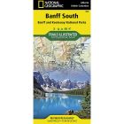
APPALACHIAN TRAIL: DAMASCUS TO BAILEY GAP No.1503
The Damascus to Bailey Gap Topographic Map Guide makes a perfect traveling companion when traversing the southwest Virginia section of the Appalachian Trail (A.T.). The A.T. in southwest Virginia travels through a culturally and historically rich area that includes fertile farmland, long, wooded ridges, and the highest mountains in the state. While the Mt. Rogers high country, just east of Damascus, is very popular with visitors, hikers can find excellent opportunities for solitude farther north on their way to the New River and Bailey Gap.
The map and trail profile provide a step by step visual guide to hiking the trail, mile by rugged mile. The Topographic Map Guide is built for all levels of hiking enthusiasts, from the day tripper to the multi month 'thru-hiker'. The front pages of the printed Topographic Map Guide include resupply information, town inset maps, camping options, and much more. Other features found on this map include: Abingdon Gap Shelter, Atkins, Bailey Gap Shelter, Bastian, Bland, Bluefield, Chatfield Shelter, Chestnut Knob Shelter, Damascus, Doc's Knob Shelter, Grayson Highlands State Park, Helveys Mill Shelter, Hurricane Mtn Shelter, Jefferson National Forest, Jenkins Shelter, Jenny Knob Shelter, Knot Maul Branch Shelter, Lost Mtn Shelter, Marion, Mount Rogers, Old Orchard Shelter, Partnership Shelter, Pearisburg, Pine Swamp Branch Shelter, Princeton, Rice Field Shelter, Saunders Shelter, Tazewell, Thomas Knob Shelter, Trimpi Shelter, Wapiti Shelter, Wise Shelter.
Ratings & Reviews
Be the first to review this product
More from NATIONAL GEOGRAPHIC
![PACIFIC CREST TRAIL MAP [IN GIFT BOX]](https://libertymountain.com/media/catalog/product/cache/4155037a17064c872f0ae7056eb73a09/6/6/667056.jpg)


![WIND RIVER RANGE SOUTH MAP [LANDER, CIRQUE OF THE TOWERS]](https://libertymountain.com/media/catalog/product/cache/4155037a17064c872f0ae7056eb73a09/6/6/667054.jpg)